It's a small world these days.
My mother was the first member of staff to be employed by the fledgling Directorate of Colonial Surveys (DCS) in 1946, soon after the end of World War Two. Her father, my grandfather, was vying to become the Director, hence her number one status. Sadly he was beaten to the position by his longtime friend, but crucially still a serving Army officer, Brigadier Hotine.
Coincidentally, my father also joined the DCS after almost seven years of foreign service with the Royal Signals - in north Africa with the Eight Army, then seconded to the LRDG and the fledgling SAS, before returning to HQ 8th Army Group for the campaigns flowing back and forth across Africa before advancing north to Sicily, through Italy and thence into Germany.
The DCS was set up to provide high quality, accurate mapping services to Britain's colonies. DCS sent out aerial survey teams and on-the-ground cartographers to virtually all parts of the globe that were then marked in red on school atlases - the Commonwealth. With Great Britain's empire shrinking fast in the troubled post-war years, the DCS became the Directorate of Overseas Surveys (DOS) in 1960, although still providing mapping for a huge number of former colonies. Only in 1980, when my dad retired, did the DOS become absorbed into the Ordnance Survey.
What has all this got to do with the image on this page?
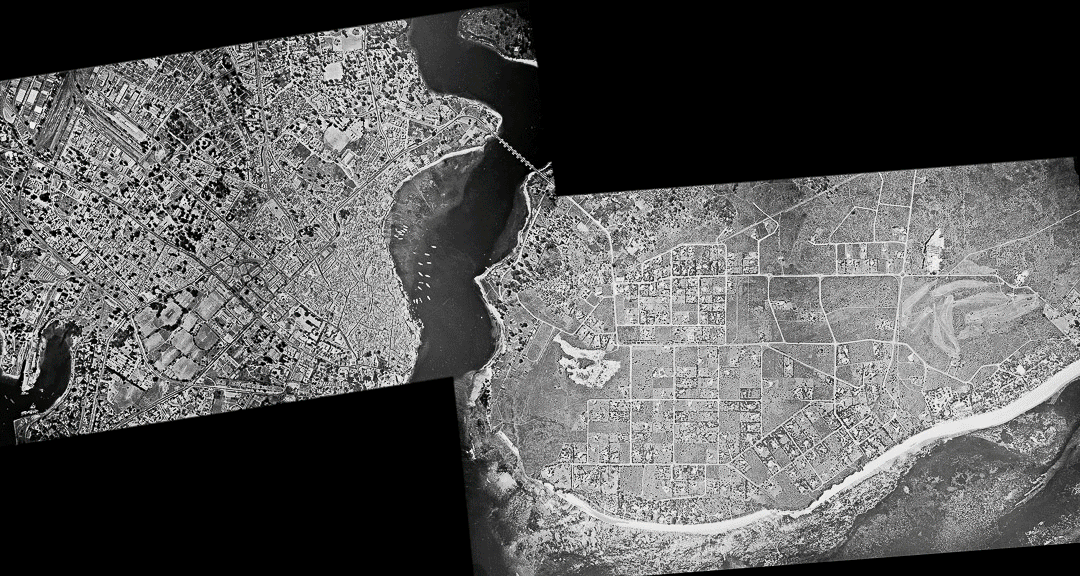
Well, amongst all his effects after he died, were a vast number of maps, stereo pairs of aerial survey photographs, wartime reconnaissance photographs, immense printing plates of maps and - lastly - a box containing glass positive 9x9inch contacts off the original 9x9inch aerial survey negative films.
Unusually the images contained no marginal information at all - no height, speed, heading or location. This was virtually unknown and it piqued my curiosity. I wasn't even sure which way round the plates should be viewed from. Were they contacted emulsion to emulsion, which should have been the correct way, or were they the result of a quick fix? I shot all the individual plates - about 9 or 10 as I recall - on a light table under a rostrum camera and then set about aligning them and trying to stitch them together. When that was finished I still had no idea where in the world the image depicted. I still had no idea when it was taken, other than certainly after 1946 and before 1980! The use of glass plates was still common up until the early 1970s because they provided a much more precise method of mapping than film, which was prone to shrinkage and distortion.
I scoured Google Earth in my spare time but always drew a blank. And then, expecting very little, I put the image on to Facebook in the hope that someone might just recognise the location. There was no feedback at all. My hopes of finding out where in the world the location was faded.
For almost two years nothing happened until I rediscovered the composite file. Importing it into Photoshop I rotated it into each of the four most likely headings - north, east, south and west and then flipped it laterally to provide a total of eight possible views which I then posted on Facebook in early October 2015.
To my surprise my old friend Simon Atkinson, a former gunner with 7 Para RHA before transferring to the RAMC and becoming CO of 4 GS Medical Regiment, responded within 24 hours. Mombasa, on the east coast of Kenya, he stated with confidence. He was absolutely correct.
So there you have it - the final piece of the jigsaw has now been dropped into place after half a century or more. I'm sure that someone with intimate knowledge of Mombasa may be able to date it with slightly more precision, based on the growth of the town, but that is not so vital.
Below is an animation, from the original composite through to a Google Earth overlay from today.
Where In The World Is This?
